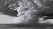
Scientist Explains How a Fire Tornado Forms
Released on 08/28/2019
[intense music]
[Neil] Winds at the surface
in excess of 140 miles an hour,
which is equivalent to an EF3 tornado
15,000 feet above the surface.
It's superheated gasses and flaming gasses
getting lifted into this violently rotating column of air.
The sun is almost entirely blotted out by the smoke.
It's this hellscape of midnight at noon and raining fire.
[Man On Phone] I can't last too long here.
[911 Operator] Okay, if you can get out safely,
get out, okay?
[Man On Phone] I can't.
Can I give you my wife's phone number?
Tell her I love her.
[Neil] This is a fire tornado.
[wind howling]
[Man] Nobody's gonna believe it at this point.
We gotta record it.
My name is Neil Lareau.
I am an assistant professor
at the University of Nevada, Reno,
and I'm an atmospheric scientist,
and we're here to talk about fire weather,
and in particular, fire tornadoes.
[wind howling]
When we're talking about winds of 140 miles an hour,
people don't really understand just how strong that is.
We're talking about lofting cars off of the ground.
We're talking about crumpling large steel structures,
potentially ripping roofs off houses,
and then you add that with flaming gasses,
and intense combustion,
and we're talking about really one of the most extreme
sort of phenomenon that you can witness.
Fire was whipped up into a whirlwind of activity,
you know, uprooting trees, moving vehicles,
moving parts of roadways.
So, let's talk about how fire tornadoes form.
True fire tornadoes have only been documented now twice.
Once in Redding, California during the Carr Fire,
and once in Canberra, Australia during 2003.
The unique aspect of the Carr Fire
was the presence of these kinda ambient shear winds
in the environment,
and that was really setting the stage for the development
of this tornado.
Then, updraft is simply a rising current of air.
In this case, generated by the heat of the fire.
We know that hot air rises,
and so we're putting a huge amount of heat
into the atmosphere right above the fire.
And all of that air is going to accelerate upward,
and so that's the primary updraft driven by the fire.
When air flows up, it also necessitates air to flow in.
All of the air that's going up
has to be replaced from somewhere,
and so it's gonna draw air in from the sides,
and this is what we might call an inflow jet,
or a fire induced wind, which is a horizontal wind
that is essentially converging from all directions
into the location of the updraft.
The other thing that we're seeing
in the case of the Carr Fire
is the presence of wind shear in the environment,
which is air flowing in different directions
adjacent to the other air streaming.
You can picture this like a highway median
with traffic going in one direction,
separated from traffic going in the other direction
over just a short distance.
This is actually,
if you picture a pinwheel or something in this flow,
actually gives rotation in that environment.
And so, that's our kind of source of initial rotation.
[wind howling]
[soft intense music]
There's something kind of interesting that's happening here,
that is what we would call a vicious cycle,
or a positive feedback.
Normally, if you don't have rotation
in this big flaming column of hot gasses
rising off of the fire,
it will readily mix with its environment.
So, you'll get these big eddies
that form on the side of the updraft
that pull in colder air from the surroundings.
They help cool off the air in there,
and dilute that air.
Once you get rotation,
you are no longer able to mix air
into this column as effectively.
So, it starts acting a little bit more like a chimney,
and the flaming can persist
through a much greater depth in the atmosphere.
And so, it's retaining its heat much better
than it would be otherwise,
and that's allowing it to stay stronger,
the updraft is stronger, the inflow winds are stronger,
and then the combustion is stronger at the surface.
So, really a vicious cycle here.
[soft piano music]
People often confuse what we would consider
to be a fire tornado with a fire whirl.
Maybe not all fire scientists or meteorologists
exactly agree on what distinguishes between fire whirls,
and fire tornadoes.
Fire tornadoes and fire whirls
both start with strong updrafts from the fire,
and strong inflows related to the fire itself,
but fire tornadoes get even bigger because the fire
is actually initiating its own weather system,
helping to concentrate the rotation in the lower atmosphere.
[soft dramatic music]
Fire tornadoes actually develop a link
to what's called an overlying pyro-cumulonimbus cloud,
which is a fancy word for fire generated thunderstorm.
And so the column of hot air rising from the wildfire
can actually then trigger its own weather system,
its own thunderstorm.
There's actually a fair bit of water vapor
inside of this big smoke plume coming off of the fire,
and as the plume gets higher and higher in the atmosphere,
it eventually reaches a point that it's actually cold enough
that it can no longer hold
the initial amount of water that it had,
and it forces that water to go from the invisible phase
into a liquid cloud droplet.
And we see this as a bright white cloud
that develops in the plume.
Every time some of that water
has to be forced into a cloud droplet,
it dumps some heat back into the atmosphere.
The fancy term that we have for this is latent heat release.
Latent heat release is when water changes phase
from water vapor, invisible water vapor,
into visible white cloud droplets,
and it dumps some heat out during that process.
And when you have millions of droplets doing that,
that amount of heat is tremendous.
And so, this is what fuels an ordinary thunderstorm,
the heat released inside of the cloud.
And so, when a fire does this,
it's kind of doubling the effect of the fire,
because we have the initial heat from the fire
that's driving this big column of air going up,
it gets deep enough,
and then it starts adding heat back into the column,
and it will rise even further into the atmosphere.
And once that happens,
the cloud really has a mind of its own,
and will really rapidly vertically develop.
[soft music]
Long distance spotting is really scary
in that you're throwing embers in advance of the fire,
which can actually go quite some distance
in front of the fire, you know, a mile in front of the fire,
and these are gonna start new fires.
And so, we can see this in Paradise for example,
where we have embers raining down from the sky,
and starting all sorts of new fires.
[sirens wailing]
[Man] This is nuts.
[vehicle reversing]
Sometimes, you'll get this pockety distribution
of things that did burn, and things that don't burn.
One house may burn because the geometry of its roof line
lets these embers build up,
or there is a fuel bed next to the house
that is very receptive to these,
whereas a more irrigated surface,
even though those embers may be falling on it,
may not ignite.
And sometimes, we see these green spaces in communities
essentially be untouched by the fire,
even though embers may be falling there.
And then just extreme flame lanes,
and flames moving horizontally through the landscape
has really devastating impacts.
In the case of fires like the Camp Fire,
or other strong wind driven fires like the Tubbs Fire
that devastated parts of Santa Rosa.
We have very strong ambient winds
moving through the environment as well,
and they just are pushing the flames,
and pushing the embers in a sheet across the landscape.
The houses add to the fuel significantly.
Once we move into town,
the fire is going to behave differently,
because the fuels are different.
You get a change in fire behavior,
and a change in the strength of your updrafts,
the depth of this big column of air
as you move into the settled area.
Those houses are very rich fuel sources for a fire.
[fire crackling]
You can't rely on just what you've seen in the past
in some of these environments right now.
Being cognizant of the factors that could go into
forming a truly devastating fire tornado,
and fire generated thunderstorms,
is an important challenge for forecasters,
and for fire managers to look out
for these events in the future,
and ultimately try to get people out of harms way
in an expedient fashion.
We can clearly see that fires have gotten bigger.
You know, we have a lengthening fire season,
globally but also here in California.
The longer fire season, the bigger fires that we're having,
essentially give us more opportunity
to experience the range of extreme fire behaviors
that are possible.
Firefighters are the ones on the front line of this,
and they're often relying on their experiences,
or their crew boss's experience with fire,
how fire has behaved in that landscape in the past,
what sort of behaviors you can expect from the fire.
But as we see these outlier events,
rules of thumb or past personal experience
are not gonna capture the full range
of potential, extreme fire behaviors.
Inside a Tornado Modeled By a Supercomputer
How Climate Change Is Already Affecting Earth
Inside the Plane Graveyard Training Future Air Crash Investigators

Scientist Explains What Water Pooling in Kilauea's Volcanic Crater Means

Bill Nye Answers Science Questions From Twitter - Part 3
Seismologist Explains How to Prepare for a Massive Earthquake
Inside the Science Behind This Incredible Water-Based Illusion
How Gravity Built the World's Fastest Jet Suit

The Best of Tech Support: Ken Jeong, Bill Nye, Nicole Stott and More

The Slow Mo Guys Break Down Slow Motion Videos